Grange Top quarry has been supplying our adjoining Ketton cement works for nearly 100 years, but its mineral reserves are running out. That’s why we are seeking to extend the quarry’s extraction area so we can secure the supply of raw materials and the long-term future of the cement works.
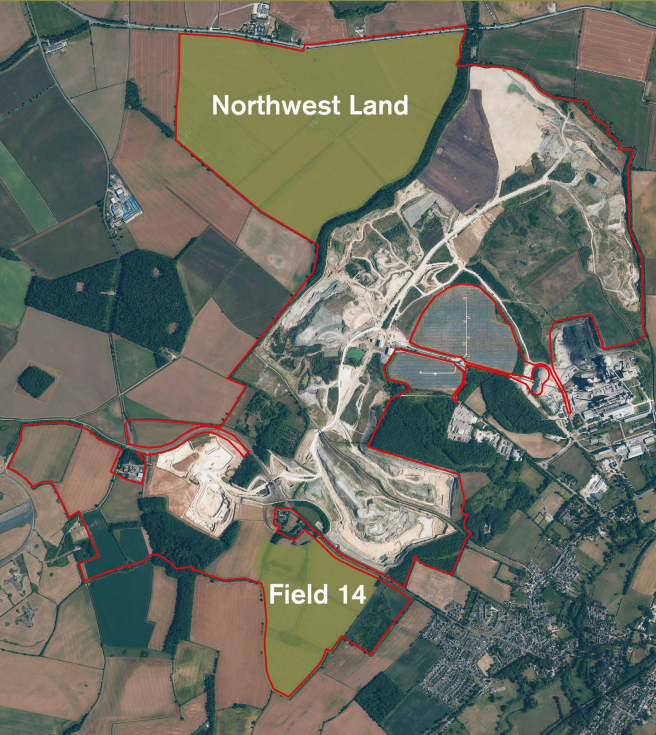
We have identified two areas already in Heidelberg Materials' ownership – the first is to the north west of the current extraction area at Grange Top, known as Northwest Land, as well as one to the south west, alongside the new Empingham Road, known as Field 14. These would provide around 25 years’ supply of limestone and clays, with all extracted materials used at our Ketton works to make cement for use in construction.
Our application to extend Grange Top, shaped by the feedback we received from stakeholders and residents, was submitted to Rutland County Council (RCC) in January 2024. The plans have been developed to ensure that they enhance nature and mitigate impact on our neighbours, as well as providing transformative improvements to footways and bridleways. Our proposed £10 milllion+ investment in a new access road to Ketton works will also reroute HGV traffic away from the villages of Ketton and Tinwell.
All planning documents can be found on Rutland County Council’s website. The local authority is now carrying out its own consultation on our proposals, with a deadline of Friday 23 February 2024.
Responding to feedback
Ahead of finalising our plans to extend Grange Top quarry we carried out extensive engagement with local stakeholders and residents, including a public exhibition. Feedback received helped inform our thinking and we would like to thank all those who responded.
Additional information on the key issues local people raised with us, including where adjustments were made in light of feedback received, are detailed in our Response Document. This was shared with all those who submitted responses into our consultation and also with key stakeholders in November 2023. This Response Document is available to download below.
The series of 3D visualisations from points around the site, developed to show how these locations will look at key stages in our project, and referenced in the Response Document, are also available below.
Ketton cement works supplies between 10-15% of the UK’s annual cement requirement and is of local, regional and national significance. It relies on the adjacent Grange Top quarry for the materials it uses in cement manufacture, but at current extraction rates, existing mineral reserves at the quarry will run out in the early 2030s. That’s why we are seeking to extend the extraction area at Grange Top so we can secure the supply of raw materials and the long-term future of the cement works.
Our proposed extension areas, Northwest Land and Field 14, form part of the mineral reserves identified by Rutland County Council (RCC) as having the potential to contribute to the county’s essential supply of cement. This means both areas are already recognised by RCC as areas for future mineral extraction to meet the needs of the construction industry and help drive economic growth.
Our planning application will encompass the proposed extension areas as well as the existing quarry and restoration scheme. Consolidating permissions at Grange Top quarry will allow for a single planning permission with one set of conditions to cover all mineral extraction operations and restoration schemes going forward.
No changes are proposed to quarry operating hours, which are 07.00 – 19.00 Monday to Friday and 07.00 – 13.00 on Saturdays, nor will we be looking to amend the existing conditions on quarry blasting. There are also no changes to the processing facilities at Ketton cement works proposed in this application.
New access road to reduce HGV traffic on local roads
Significantly, our plans do include the construction of a new 3km access road northward from the cement works across our site to a new roundabout junction with the A606, to the west of Shacklewell Hollow. Once constructed, all HGVs will use this new route, with 95 per cent of traffic travelling east along the A606 to the A1. This investment will substantially reduce Heidelberg Materials HGV traffic on the A6121 High Street /Stamford Road passing through Ketton and Tinwell.
Our plans also include new and upgraded public rights of way which will greatly enhance connectivity in the local area and have been designed to give priority to recreational users.
Environment and restoration
A full environmental impact assessment (EIA) has been carried out to identify any potential impacts of our plans and how they can be mitigated. It includes recommendations for a series of measures to minimise the potential impacts of:
Landscape and visual
Ecology
Soil
Blasting and ground vibration
Ground and surface water
Noise
Dust and air quality
Traffic
Archaeology and heritage assets
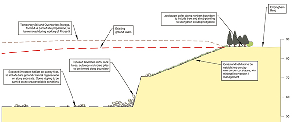
Particular attention has been paid to landscape and visual impacts, with our proposed mitigation measures including retaining perimeter hedgerows, screening the new parts of the quarry with 3-5m high landscaped screening bunds to protest views, contain noise and minimise dust.
We’ll also work closely with RCC’s highways team to ensure that the new site access junction with the A606 meets modern safety requirements and includes suitable screening measures.
The approved quarry restoration scheme for Grange Top remains unchanged and we’ll build on our success to date with the proposed scheme for the Northwest Land and Field 14 areas. The final restoration scheme will return the quarry to a mix of agriculture, nature conservation and amenity uses. It will only use materials derived from the site, without the need for any imported fill materials. This will allow the site to be restored as workings move around the quarry.
Benefits of our proposals
Ketton cement works already supplies over 10% of the UKs cement. As well as ensuring supplies of this essential construction material, extending Grange Top quarry will also secure the long-term future of Ketton cement works and those that rely on it for employment.
The cement works and quarry is one of the largest employers in the county, employing over 240 people in direct jobs, and many more in the supply chain. Our operations also help underpin local services, as we’re by far, the single biggest contributor to business rates in Rutland.
In addition, we’re proud of the role we play in the local community and will continue to support local charitable initiatives as well as providing career opportunities via our apprenticeship and trainee manger programmes.
Further information on our proposed extension of Grange Top quarry shared at our recent public exhibition can be viewed here.
The two proposed extraction areas – Northwest Land and Field 14 – are recognised by Rutland County Council as areas for future extraction to meet the needs of the construction industry and help drive economic growth. Both areas are already owned by Hanson, have good quality mineral reserves and are easily accessible from the works.
Extraction would take place at the same time across both areas, providing around 25-30 years of minerals supply (depending on market requirements) for the cement plant – once current permitted reserves have been exhausted.
It comes down to geology – with both areas needed to supply the raw materials required for cement manufacture at Ketton cement works. Field 14 will supply around 4.5 million tonnes (mt) of clay and 6.4mt of high carbonate limestone, plus silica limestone. Northwest Land – which has no clay – will provide around 28mt of high carbonate limestone, plus silica limestone. Both areas will be worked simultaneously.
Independent research carried out by authorities around the world into vibration levels has helped to formulate safe blasting criteria, with the UK having some of the most stringent levels in place.
At Grange Top we operate within the regulations set out in our existing planning conditions and will continue to do so in the proposed quarry extension areas. These regulations have well-defined limits on ground and air vibration (air over pressure) and ensure that there is no risk of structural damage to nearby homes or buildings. The limits employed sit well within the defined limits of acceptability defined in government guidance.
The potential air quality and dust hazards from quarries are well understood and addressed via stringent regulatory controls. Our current operations at Grange Top include a range of measures, including the use of bowers and sprinklers using recycled water to minimise dust generation. The quarry’s regular dust monitoring programme – including at off-site receptor locations – shows our full adherence with the regulations, which form part of our planning conditions.
This approach will continue with the proposed extension areas, with the development of 3-5m high screening bunds and extensive planting also helping to contain dust within the site.
Field 14 is already well-screened on its eastern boundary, with previous tree and shrub planting now well-established. In addition, we will create 3-5-metre-high landscaped screening bunds along the eastern and northern boundaries to protect views, contain noise and minimise dust.
Hedgerow thickening and additional tree and shrub planting will also take place around the perimeter, helping to protect views from Empingham Road. In addition, the need to remove overburden, with the creation of cut slopes, to access the limestone, means that the quarry operations will be mostly screened from view.
The principal reason for the new access road is to redirect HGVs away from Ketton and Tinwell villages. The existing access road onto Ketton High Street remains completely serviceable, but we are aware of local concerns about HGVs using the A6121 High Steet/Stamford Road.
The new 3km access road will cost around £10 million to build and will run from the cement works to a new roundabout junction with the A606, west of Shacklewell Hollow. Traffic volumes from the plant will remain in line with current levels but once constructed, all Ketton works vehicles will use it to access the site – reducing HGVs passing through Ketton and Tinwell.
Our studies show that 95% of HGVs travel from the works towards the A1. This means that most HGVs will turn right where the new access road meets the A606. The small proportion of HGVs turning left along the A606 would be the equivalent of 5 additional HGVs a day over current levels – a fraction of the total number of non-Ketton HGVs using this route.
The route will run along the quarry floor so that traffic using it will not be visible from outside the quarry.
The junction with the A606 itself will be designed to meet all modern safety standards and will include extensive screening measures.
Work on the new access road to Ketton works will commence once Phase 1 of extraction in the Northwest Land has been completed.
Before we can start work we need to complete several preparatory steps. These include developing a landscape buffer on Northwest Land’s eastern and northern boundaries along with the creation of screening bunds using soil removed from the site ahead of extraction, thickening of hedgerows and planting of new trees and scrubs to the eastern and northern boundaries. These measures will protect Shacklewell Hollow SSSI and ensure that quarry operations and the new access road and its junction with the A606 are screened once constructed.
Plus, we will also have to create the cutting into which the new access road will be situated. Positioning the road at a lower level than the surrounding land this way will contribute to its screening from A606.
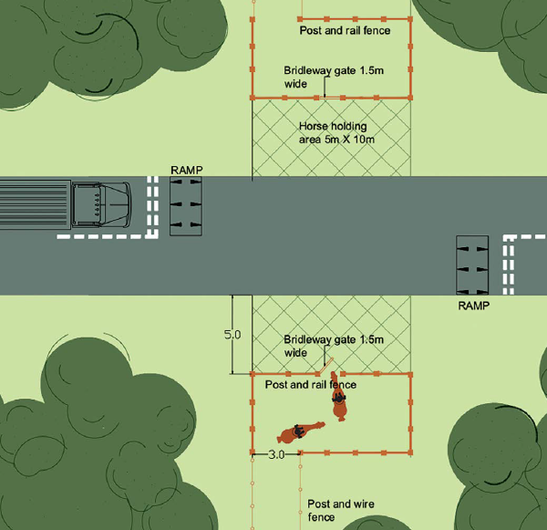
Our proposals include constructing a new horse-friendly crossing. Bridleway users will have priority and the design, with open visibility so horses and drivers can see each other, has been developed in line with the British Horse Society’s advice on road crossing for equestrians. The staggered design includes a grass horse holding area and the vehicle Give Way markings are positioned so that horses and vehicles are kept at least 6m apart.
There will be a haul road specifically for quarry plant through the Northwest land area. This is separate from the new access route to Ketton works.
To keep quarry plant and machinery away from recreational users of bridleway E226 we are proposing a bridleway bridge where the two intersect. The new bridleway bridge will go over the haul road – with the floor of the road lowered so that the new bridge remains at the current level of the bridleway. While the new bridleway bridge is being constructed, we will seek a temporary diversion to E226.
Our full application to Rutland County Council (RCC), is expected to be submitted before the end of 2023. RCC will then consult with statutory bodies and invite comments from residents before making its decision.